
THE JOURNEY OF THE IWALANI!
NECKER BECOMES HAWAII’S!
The Islands of the Hawaiian Archipelago!
In the afternoon of May 25, this town was all astir at the news that the steamship Iwalani was headed on a long expedition. At 5:20 of that evening, the Iwalani sailed on its mystifying mission. On board was J. A. King, Minister of the Interior, and the crew was increased by ten more sailors. Ka Leo¹ newspaper was much alarmed thinking that the Provisional Government was looking for a place to keep all of the royalists [anee alii]. The royalists proved this worthless piece of news by Ka Leo printing a letter that they found in some dung, but the people…
THE HAWAIIAN ARCHIPELAGO.
…of proper thinking, they were not anxious. The wonder of the people was highly escalated because the British warship Champion followed half an hour after the Iwalani left. And as is usual in Honolulu nei, news soon spoke of the warship chasing after the Iwalani. These senseless ideas were let go when the Iwalani returned on Tuesday evening, May 29.
From what was said by Captain Freeman of the Iwalani, they passed Nihoa in the evening of Saturday, May 26, and at 11 o’clock on the following morning, May 27, the anchor of the Iwalani was let down on the leeward side of Necker [Neka] Island, 41 hours sailing from Honolulu. The skiff was let down and Captain King, Captain Freeman, engineer Norton, along with seven sailors went on.
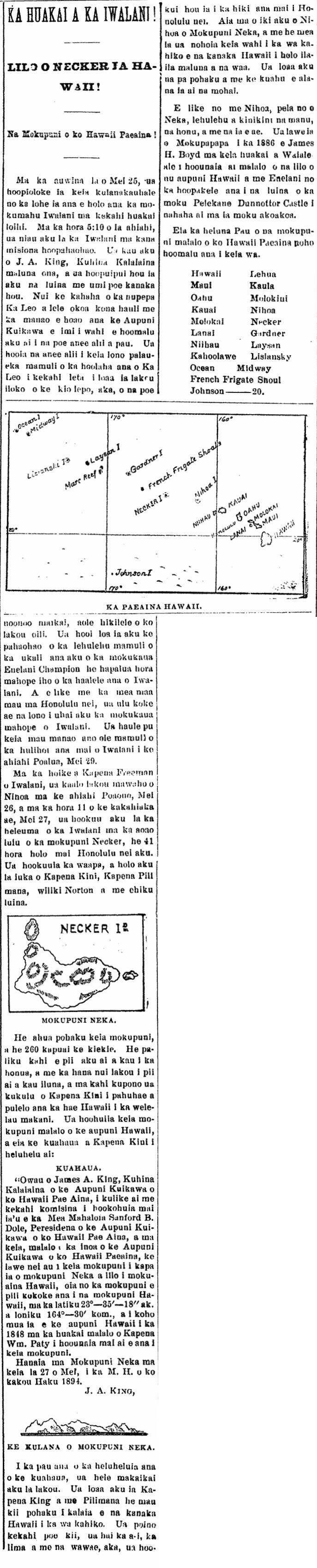
NECKER ISLAND.
This island is a heap of rocks, and is 260 feet tall. There is a steep cliff rising from the ground, and it was with great effort that they climbed up until a proper place to where Captain King stood a flagpole and the Hawaiian flag waved in the wind. This island was annexed to the Hawaiian nation, and this is the proclamation that Captain King read:
PROCLAMATION.
“I, James A. King, Minister of the Interior of the Provisional Government of the Hawaiian Islands, in pursuance of a commission granted to me by His Excellency Sanford B. Dole, President of the Provisional Government of the Hawaiian Islands, do hereby, in the name of the Provisional Government of the Hawaiian Islands, take possession of this island known as Necker Island as a part of Hawaiian territory; the same lying within the Hawaiian archipelago, in latitude 23º—35’—18″ N and longitude 164º—30’—00” W. and having been claimed by the Hawaiian Government as Hawaiian territory since the year 1845, when an expedition under Captain William Paty was sent to survey said island.
Done at Necker Island this 27th day of May, in the year of our Lord one thousand eight hundred and ninety-four. J. A. King.
PROFILE OF NECKER ISLAND.
When the reading of the proclamation was over, they went on a tour. Captain King and Freeman [Pilimana] found a number of stone figures [kii pohaku] carved by Hawaiians in the olden days. Some of the figures were damaged: the necks, hands, and legs were broken, but they will be reattached upon reaching Honolulu nei. Necker Island is a little beyond Nihoa, and it seems that it was inhabited in ancient times by Hawaiians who travelled there on canoes. Found were stone walls and altars where sacrifices were made.
Like with Nihoa, Necker has a great multitude of birds, turtles, and other fish. Mokupapapa was taken in 1886 by James H. Boyd on the expedition of the Waialeale sent under the expense of the nations of Hawaii and England to save the sailors of the British ship Dunnottar Castle which broke into pieces on that coral island.
These are All of the islands under the dominion of the Hawaiian Archipelago at this time.
Hawaii Lehua
Maui Kaula
Oahu Molokai
Kauai Nihoa
Molokai Necker
Lanai Gardner
Niihau Laysan
Kahoolawe Lisiansky
Ocean Midway
French Frigate Shoal
Johnson———20.
¹Ka Leo o Hawaii
(Kuokoa, 6/2/1894, p. 3)
Ka Nupepa Kuokoa, Buke XXXIII, Helu 2, Aoao 3. Iune 2, 1894.
