HONOLULU.
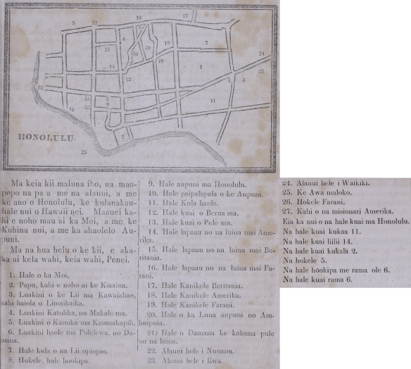
In the picture above, clear are the yards and streets, and the layout of Honolulu, the great city of Hawaii. Here is where the King lives permanently, as well as the Prime Minister, and the Nation’s Legislature.
By the numbers on the picture, each place is clearly recognized, Thusly:
1. Residence of the King.
2. Fort, where the Governor lives.
3. Church of the King at Kawaiahao, where Armstrong preaches salvation.
4. Catholic Church, of Maigret them.
5. Smith’s Church at Kaumakapili.
6. Haole church at Polelewa, of Damon
7. School of the Young Chiefs
8. Hotel, “welcoming house”.
9. Government building at Honolulu.
10. Government printing house.
11. Haole school.
12. Store of Brewer them.
13. Store of Pele [Bell?] them.
14. Infirmary for the sailors from America.
15. Infirmary for the sailors from Britain.
16. Infirmary for the sailors from France.
17. British Consulate.
18. American Consulate.
19. French Consulate.
20. Building of the American diplomats.
21. House of Damon the pastor of the sailors.
22. Street going to Nuuanu.
23. Street going to Ewa.
24. Street going to Waikiki.
25. Inner Harbor.
26. French Hotel.
27. Place of the American missionaries.
This is the number of stores in Honolulu.
Clothiers, 11.
Small shops, 14.
Auction houses, 2.
Hotels, 5.
Establishments not selling liquor, 6
Saloons, 6.
(Elele, 10/7/1845, pp. 105–106.)

