Titcomb’s list of fishes, 1940.

TO THOSE WHO KNOW THE NAMES OF FISHES AND THEIR DESCRIPTIONS

(Written by M. TITCOMB)

Here below is a list of names of some fishes of Hawaii nei that are found in the book of names in the Kamehameha Museum [Hale Hoikeike o Kamehameha].

akaka, akeke, akiki, akilolo, aku; variety, —aku kina’u, akule; also called aku-a (?), akupa, alaihi, alaihi kalaloa or kakaloa or kahaloa, alaihi lakea, alaihi mahu, alaihi maoli, alalana, alalauwa, alamo’o, alea, aleihi, aloalo, alo’ilo’i, alukaluka, ama’ama, pua ama’ama; pua ama; pua kahaha, ama’ama, anae, amo’omo’o, amuka; puakahala, ananalu, a-niho-loa, aoaonui, apahu, api, apoha, apu’upu’u, a’u, a’u kaku; kupala, a’u kuau-lepa, a’u lepe (iheihe; auki), a’u papaohe, aua’a auae, aualaliha, aua’u; ahaaha, auau ki, auki, auku, awa; awa-aua; awa-awa, awalo, awala; awela; awela, aweoweo.

e, e’a, eheula, ehu, enenue, hahalalu, halalua, ha hilu (?), hahili, haie’a, hailipo, halahala, halaloa, hahalua, hanaui; mokumokuhanui, haoma, hapuu, hapuupuu, hauliuli puhi, heahaaha, hihimanu; lupe, hilu, hilu eleele, hilu lauwili, hilu melemele, hilu pano, hilu pilikoa, hilu ula, hilu uli, hinalea, hinalea akilolo, hinalea eleele, hinalea iiwi, hinalea lauwili, hinalea lipoa, hinalea lolo, hinalea luahine, hinalea nukuiwi, hinalea nukuiwi-ula, hinalea nukuiwi-uli, hinalea nukuloa eleele, hinalea nukunuku loa, hinalea mananalo; ananalo, hinana, hi’ukole, hi’u-ula, hoana, hololua, hou huhune.

[This was the beginning of a series of lists of fish names appearing in the Hoku o Hawaii, and running until it seems like August 28, 1940.]

(Hoku o Hawaii, 6/5/1940, p. 2)

I NA POE I PAA KA INOA O NA I'A LIKE OLE AME KO LAKOU ANO

Ka Hoku o Hawaii, Volume XXXV, Number 6, Aoao 3. Iune 5, 1940.

Fishes, Margaret Titcomb, and the Bishop Museum, 1940.

A LETTER

May 25, 1940.

Mr. J. B. Dixon, Circulation Manager,
Ka Hoku O Hawaii,
P. O. Box 1004
Hilo, Hawaii, T. H.

My Dear Mr. Dixon,

I am pleased to hear that you are willing to entertain with aloha my clarification of the publishing of a list of fish names and your running it complimentary on your part. Enclosed is my check for the total of $2.¹

I believe that it would be a fine thing to publish it in portions each week. You and Mr. Anakalea have the ability to edit this kind of thing, and to throw out the bait upon the water.

I am looking at the list of fish names that we have, they are found in various collections, and they are not edited completely. Therefore, I will send the remainder of the list of fish names.

Happy thoughts and good wishes on your Commemorative Anniversary Edition and with hopes that this will be printed before the 11th of June, it will perhaps be something beneficial.

Yours truly,

Margaret Titcomb
Librarian.

[This is no doubt a precursor to the publication Margaret Titcomb did with Mary Kawena Pukui, “Native Use of Fish in Hawaii,” first published in 1952 as Memoir 29 of the Polynesian Society, Wellington, New Zealand. It is currently available in book form from University of Hawaii Press.]

¹It is interesting to note that the cost (prepaid) for a year’s subscription of the Hoku o Hawaii was only $2.00. This is the same cost as a year’s subscription for the Hoku o ka Pakipika and the Nupepa Kuokoa in 1861!

(Hoku o Hawaii, 6/5/1940, p. 2)

HE LEKA

Ka Hoku o Hawaii, Volume XXXV, Number 6, Aoao 3. Iune 5, 1940.

Nice advertisement for fishing nets and other equipment! 1902.

WE HAVE FISHING SUPPLIES

Here within our stock of fishing equipment are Nets [Upena] of all sorts and sizes as per your desires priced right.

We also have Hooks [Makau] which are very sharp and fine at very low prices. We also have Line [Aho] and Rods [Mokoi paeaea] and large Hooks good for large Fish as well as other fishing accessories.

PEARSON & POTTER CO., LTD.   Hotel and Union Streets.

(Kuokoa, 8/15/1902, p. 5)

EIA IHO NA LAKO LAWAIA

Ka Nupepa Kuokoa, Buke XL, Helu 33, Aoao 5. Augate 15, 1902.


Kau ka pea, holo ka waa, 1980.

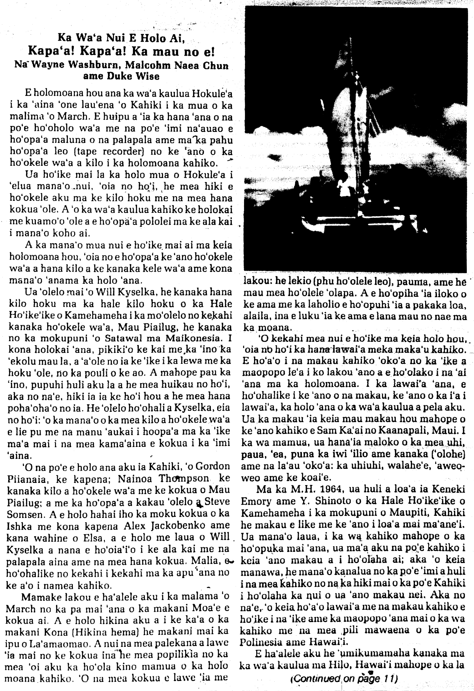
HOKULEʻA SAILS AGAIN

Hold on to the course! Hold on to the course! Continue On!

by Wayne Washburn, Malcolm Naea Chun and Duke Wise

In early March the Hokuleʻa will again set sail in hopes of reaching first landfall somewhere near Tahiti. Crewmen and scientists will concentrate efforts on documenting the thinking process, and methods, which may have been used by the ancient Polynesian navigators.

Without first voyage demonstration to the modern world two important findings. First, was that navigation by the stars without use of modern navigational instruments can be successfully used when travelling between Tahiti and Hawaii. Second, a Polynesian double-hulled canoe without keels or deep centerboards is able to sail to windward, and thus maintain planned course. For the present voyage celestial navigation will once again be of primary importance. Where the first voyage showed that celestial navigation was possible, the presēnt will pay particular attention to the recording of the thought process of the navigator.

Dr. Will Kyselka of the Bishop Museum Planetarium, and an assistant to the project, cited an incident involving a highly skilled non-instrument navigator from Satawal, Mau Piailug. Once caught in a storm for three days, Mau was unable to sail or use celestial markers for assistance. After the storm, though his course direction had been turned around many times, Mau miraculously found his way home to his tiny atoll of Satawal. Dr. Kyselka suggested that maybe there are maps within some of the more skilled navigators’ minds. He mentioned that pigeons are said to find their bearings in flight by being able to sense the difference magnetic fields given off by certain structures. Using the changes in magnetic fields the pigeons are able to draw a mental map and find their way home. Did the Polynesians possess this ability or something which would enable them to find Tahiti and Hawaii with regularity?

Captaining the voyage down will be Gordon Piianaia. Navigating for the trip will be Nainoa Thompson. There to assist Thompson will be Mau Piailug, the navigator from the 1976 voyage. Crew member Steve Somsen will be documenting the navigation process. This will be done by conferring with Nainoa and Mau and then orally recording it through the use of a tape recorder. Hopefully this will shed more light on the Polynesians’ navigational thought process.

The Ishka, a sailing vessel captained by Alex Jackobenko with assistance from his wife Elsa will follow some distance behind Hokuleʻa. Dr. Kyselka will be on board to study and document the route of the Hokuleʻa using modern navigational instruments and charts. On completion of the voyage the two styles of navigation will be compared for scientific value.

March has been designed for departure because it is the season that tends to favor the northeast tradewinds which are important for the first half of the voyage. Like the 1976 voyage the canoe will travel southeasterly for about 1000 miles. Once “easting” is accomplished winds blowing from the southeast will be used to rēach first landfall or Tahiti from a windward approach. This “easting” is important in that not enough movement in that direction might cause them to sail west of Tahiti and miss the islands completely. Certain safety features have been added to the canoe in order to avoid swamping problems encountered in previous inter-island trips. The gunwales and hatches have been raised to help prevent water seepage into the hulls. Also on board will be six hand pumps, a radio and flares. The radio will be used to notify the Hokuleʻa’s escort boat in case of an emergency. Certain sections of the hulls will contain inflated rubber. In the event that the hulls are accidentally smashed these will enable the canoe to remain afloat. Although non-instrumental navigation is the paramount research project of this voyage, other projects are being encouraged on a smaller scale. One of these is to fish using traditional types of fishhooks to learn how they were used. This hopefully will also provide a supplement to the crew’s diet by adding fresh fish. While conducting the fishing experiments crew members will record how the differences of fishhooks: design, material and size; the speed of the canoe; the types of fish caught and other factors affect fishing in the deep sea. These fishhooks are being faithfully copied from authentic fishhooks under the supervision of Sam Ka’ai of Kaanapali, Maui. Ancient fishhooks were made from materials such as shell, coral, turtle shell, dog and human bones and even hard woods.

In 1964, Drs. Kenneth Emory and Y. Sinoto of the Bernice Pauahi Bishop Museum, found a Tahitian one-piece fishhook at Maupiti in the Society Islands. They proposed a theory that this type of fishhook is the same as found in various sites in Hawaii. After its initial introduction they believe it became a major type used by the ancient Hawaiians, Today, other anthropologists are not as certain if Tahitian migrations caused the popularity of this fishhook, but nonetheless, the experiments conducted by crew members of the Hokuleʻa should provide some information that may help the on going research in finding common links between the ancient Hawaiian society and the Southern Polynesians.

With a crew of fourteen, the Hokuleʻa is scheduled to depart from Hilo on…

(Ke Alahou, 2-3/1980, p. 1)

Ka Waʻa Nui E Holo Ai...

Ke Alahou, Helu 4, Aoao 1. February/March 1980.

…the first favorable day after March 2.

Editor’s comment: The projects conducted by the crew of the Hokuleʻa remind us of the legend of Hema, a pan-Polynesian legend about a great super chief.

Hema was the son of Aikanaka and his wife Hinaaimalama of Hana, Maui. Hema’s wife was called Hina-polipoli and they lived at Kipahulu, East Maui. When she was pregnant with their second child, Hina craved for the eyeball of a large fish of the open, deep sea. This fish had a tail like that of the shark, Ahiale and was called Kekukaipaoa.

Hema prepared all his fishing gear and made ready the double-hulled canoe by loading enough food and water for several days. He covered his canoes with many mats, lashing them down with cords so that sea water could not seep in. When the canoe was covered securely, he hung his fishing line, Pupuwaiakolea, above the top of the poles that were between the hulls of the canoes. He put the end of the line through a knot he had tied and then he set up his cord calabash, which was called Kumaaiku. He took out the fishhook and tied the end of the fish line tightly around it fastening it to the pole.

Hema’s fishhook was not made of human bone like some of those found in the Bishop Museum, nor was it made of whale bone or turtle shell like Manaiakalani. It was made of a branch of wood whose name is not known today. The kikala or the intersection of the barbs, is found at the branch closest to the trunk of the tree. When this branch is laid flat, three other branches project from it. These branches are broken so they are short and sharp. This joint is called lehua, perhaps after the flower. The shank knob of the fishhook is called muʻo and this is where the fish line is tied. The name of Hema’s fishhook is Papalahoʻomau and still survives today as the name of the Congregational Church in Kipahulu.

It was later on in the story that Hema was blown off course and his voyage to Kahiki or Holani-ku began.

(Alahou, 2-3/1980, p. 11)

ʻelua o March.

Ke Alahou, Helu 4, Aoao 11. February/March 1980.

Mary Robins and a fun fishing story, 1918.

NEWS FROM THE LIGHT STATION OF HONOLULU HARBOR.

Please be patient with me, O Editor of the Kuokoa Newspaper, and include my little news from the day of Washington’s birthday.

At 3 p. m., we went walking around the pier of the lighthouse to check out what was new; we saw the fireworks and heard its sound, and saw an American flag with a balloon carrying this flag so beautiful to see.

After that, we spotted a huge octopus headed towards us, then it went below the pier, stayed there quietly for a minute or so, and then we saw it again beneath some big rocks; I went down to go find a place where I could stick my hands in, and when I saw it was the right time to grab the big hee, there were two things I felt at the same time, fear and regret; I pushed aside my fear and it was the feeling of regret that I concentrated on, whereupon I grabbed the head of the hee, and its tentacles latched on tightly to the rocks, and it thought it would be victorious, but it would not be triumphant over me because I had its head grasped tightly in my hands. Continue reading

Paaiea Pond, part 4 and final, from the pen of J. W. H. Isaac Kihe, 1914.

SOME STORIED LANDS OF KONA

Written for the Hoku o Hawaii by ka Ohu Haaheo i na Kuahiwi Ekolu¹

PAAIEA POND

Meeting with Kolomu’o and Pahinahina.

When the flames subsided, the fire disappeared, and this is why it was assumed it was the fire of the Uau Bird Catchers in the Mountains.

In the middle of that night, the lava emerged and flowed like water below a crater on the side of a peak called Kileo, and it is black, shiny pahoehoe that remains there to this day. And from there the lava dove down and resurfaced makai side and several deep fissures cracked open and remain near the village that Mr. Maguire lives at.

The lava dropped down again and on the makai side of the old road there opened up a small furrow six (6) feet wide, and from here the lava began to flow and overran everything before it.

Villages were destroyed and some people died as victims to the wrath of the Goddess of the crater, because of the denial of Pele by that Konohiki [Kepaalani] which the Alii [Kamehameha I] stationed to oversee all of his wealth. And when the Konohiki saw the lava burning everything and turning into pahoehoe and gorging away, he finally realized that the old lady was Pele that appeared before him asking for fish, palu, and then shrimp, and he regretted this filled with dread and great fear. Continue reading

Paaiea Pond, part 3, from the pen of J. W. H. Isaac Kihe, 1914.

SOME STORIED LANDS OF KONA

Written for the Hoku o Hawaii by ka Ohu Haaheo i na Kuahiwi Ekolu¹

PAAIEA POND

Meeting with Kolomu’o and Pahinahina.

When the woman left that place at the seaside of Kaelehuluhulu, she arrived in the uplands of Keoneeli, a place that is renown to this day called Kepuhiapele [‘the scorching of Pele’], a heap of aa lava that is almost 200 Feet high, downside of the place where J. A. MaGuire [known also as Keoni Kaimana] is living.

When the woman arrived there, there were two girls named Kolomu’o and Pahinahina broiling breadfruit, while the parents were away farming. This was a huge town during those days, with many people living there. When the woman met up with the girls broiling ulu. The woman said, “The ulu that you are cooking is done.” One of the girls responded, “We are cooking ulu, but it is not totally done.”

The woman went on, “When you ulu is cooked, who will partake of it first?” “La’i, my god, will eat first.” “So La’i is a powerful akua?” “Yes, La’i is powerful.” The name of this girl was Kolomu’o, and the area beneath that scorching of Pele is famous to this day and called Kolomu’o, and famous too is the Opelu fishing shrine [Ko’a] at the beach of Kaupulehu.

Then the woman asked the other girl, Pahinahina, “And when your ulu is done, who is it for?” “It is for Pele Honuamea, my god.” “Then it is our ulu; your ulu is cooked, let the two of us partake in it.” Pahinahina agreed, and the ulu was peeled [makikoe²] and eaten up. Continue reading

More on fishponds, 1901

FISH PONDS.

The most interesting of the fishery resources of the islands are the fish-ponds. This is the only place within the limits of the United States where they are found on such an immense scale and put to such general and beneficent use. The time of the building of many of these ponds goes back into the age of fable, the Hawaiians, for instance, attributing the construction of one of the most ancient, the deep-water fish-pond wall at the Huleia River on Kauai, to the Menehunes, a fabled race of dwarfs, distinguished for cunning industry and mechanical and engineering skill and intelligence. Many of the very old ponds are still in practical use and look as though they would last for centuries yet. As the ponds were originally owned by the kings and chiefs, it is very probable that most of them were built by the forced labor of the common people. There is a tradition amongst the natives that Loko Wekolo (Wekolo pond), on Pearl Harbor, Oahu, was built about 250 years ago, and that the natives formed a line from the shore to the mountain and passed the lava rock from hand to hand till it reached the shore where the building was going on without once toughing the ground in transit. As the distance is considerably over a mile, this speaks well for the density of the population at that time.

The ponds are found principally in the bays indenting the shores of the islands, the common method of construction having been to build a wall of lava rock across the narrowest part of the entrance to a small bay or bight of land and use the inclosed space for the pond. They were also built on the seashore itself, the wall in this case being run out from two points on the shore, some distance apart, in the shape of a half-circle. Most of the Molokai fish ponds were built in this manner. A few were constructed somewhat interior and these are filled by the fresh-water streams from the mountains or by tidal water from the sea carried to them by means of ditches. Most of the latter are on Oahu, near Honolulu. The Nomilo fish pond at Lawai, on Kauai, is formed from an old volcanic crater with an opening toward the sea, across which a wall has been built, and as the opening is below the surface of the sea the tide plays in and out when the gates are opened.

In the sea ponds the walls are about 5 feet in width and arc built somewhat loosely in order that the water can percolate freely. The interior ponds have dirt sides generally, although a few have rock walls covered with dirt, while others have rock walls backed with dirt. The sea ponds generally have sluice gates which can be raised or lowered, or else which open and close like a door. In the interior ponds there are usually two small bulkheads with a space about 8 feet square between them. Each of these has a small door which usually slides up or down. When the tide is coming in both doors are opened and the fish are allowed to go in freely. When the tide turns the doors are closed. When the owner wishes to remove any of the fish he generally opens the inner door when the tide is ebbing. The fish rush into the narrow space between the bulkheads, from which they are dipped out by means of hand dip nets. In the sea ponds the gate is opened when the tide is coming in and when it turns it is closed.

There is usually a small runway, built of two parallel rows of loosely piled stones from the gate to about 10 feet into the pond. As the fish congregate in this runway when the tide is going out, it is very easy to dip out the supply needed for market. Seines and gill nets are also swept around the inside of the ponds at times in taking fish from them, and as they are quite shallow this is done easily.

The sea ponds usually contain only the amaama, or mullet, and the awa. In the fresh and the brackish water ponds gold-fish, china-fish, oopu, opai [opae], carp, aholehole, and okuhekuhe are kept. Practically no attempt at fish-culture is made with these ponds. Besides the fish which come in through the open gates, the owner usually has men engaged at certain seasons of the year in catching young amaama and awa in the open sea and bays, and transporting them alive to the fish ponds. They are kept in the ponds until they attain a marketable size, and longer frequently if the prices quoted in the market are not satisfactory. They cost almost nothing to keep, as the fish find their own food in the sea ponds. It is supposed that they eat a fine moss which is quite common in the ponds.

There are probably not more than one-half the number of ponds in use to-day that there were thirty years ago. There are numerous reasons for this, the principal ones being as follows:

1. The native population is dying off rapidly, and where there were prosperous and populous villages in the early years of the last century there is practically a wilderness now. Owing to this depopulation there would be no sale for fish in the immediate neighborhood of the ponds there, the only place where it could be sold owing to the difficulty in transporting fish any distance without the use of ice, and the ponds would naturally be allowed to go to decay, the walls breaking down from the action of storms, and the sea filling them with sand when they are located on the immediate shore. This condition of affairs is especially prevalent on Molokai.

2. Two of the important crops of the islands are rice and taro. As both must be grown in a few inches of water, and are very profitable crops, a number of the interior ponds were turned into rice fields and taro patches. Oahu has shown the greatest changes in this regard.

3. On Hawaii ponds were filled up by the volcanic lava flows of 1801 and 1859. The Kamehameha fish pond, which was filled up in this manner in 1859, was said to have been the largest on the islands. Only traces of it are now to be found on the beach.

4. At Hilo, on Hawaii, some ponds, mostly quite small, are so filled with the water hyacinth that it is impossible to work them any more. This year a few of the best of these were cleaned out, but as there is very little money to be made out of them, and their ownership is in dispute, there is but little desire to do much to build them up.

5. Other ponds have been filled up to make way for building operations and for other purposes. This is especially true of ponds in and around Honolulu and Lahaina. There used to be a number of fish ponds on Lanai, but they have all been allowed to fall into decay.

A number of ponds are kept up by their owners merely as private preserves, as it were, the fish taken from them being either consumed by the owner’s household or given to friends. These are scattered all over the islands.

The following is a rough list of the fish ponds still in existence, or traces of which remain, together with their area and a statement so far as possible of their present condition. There is no great claim to accuracy in this list, as many of the ponds are in inaccessible regions of the islands, and in such cases the writer was obliged to depend upon others for reports as to their present condition:…

[For the rest of this report showing the locations, names, and sizes of the many loko i’a across the Hawaiian Islands, and fish produced at the time of the report, etc., etc., see: U. S. Commission of Fish and Fisheries, Part XXVII, Report of The Commissioner for the Year Ending June 30, 1901.

The fish pond report is a section of Commercial Fisheries of the Hawaiian Islands, by John N. Cobb, Agent of the United States Fishing Commission, which runs from page 381 to 499.

Also of interest (actually the whole report is interesting), is  Preliminary Report on an Investigation of the Fishes and Fisheries of the Hawaiian Islands, by David Starr Jordan and Barton Warren Evermann, which is found from page 353 to 380. ]

Paaiea Pond, part 2, from the pen of J. W. H. Isaac Kihe, 1914.

SOME STORIED LANDS OF KONA

Written for the Hoku o Hawaii by ka Ohu Haaheo i na Kuahiwi Ekolu¹

PAAIEA POND

The old woman replied. “I have come to the alii. I live in the uplands, and grew hungry for fish, so I got up and made the descent thinking that the Konohiki of the alii would be the friend here at the ocean side from whom I could receive something fishy to return upland with.

The Konohiki immediately answered. “Your trip will not be rewarded for the all the fish belongs to the alii.” “If I can’t have fish, then what about some palu?”² “There is no palu for you, it is for the alii. This is a work day for the alii; the people care for him, and I am placed here to oversee the wealth of the alii and the wealth of all of his dependents.”

“Both the Aku and the palu are kapu to the alii, as well as the amaama from the pond,” Kepaalani said, “they are restricted for the alii.” “If those are kapu, what about some small Aholehole or a little shrimp?” “Kahaha! Perhaps you can’t hear; all of those things are for the alii.” Continue reading

Paaiea Pond, from the pen of J. W. H. Isaac Kihe, 1914.

SOME STORIED LANDS OF KONA

Written for the Hoku o Hawaii by ka Ohu Haaheo i na Kuahiwi Ekolu¹

PAAIEA POND

Paaiea was a great pond almost like the ponds of Wainanalii and Kiholo. In the olden days, when the great ruling chiefs were living, and when these fish ponds were full of the riches of Awa, Anae, and Ahole, along with all sorts of fish which swam within.

During that time, Konohiki were stationed, and he was the guard of the pond that watched over the pond and all things, as here we are talking about Paaiea Pond which was destroyed by lava and became pahoehoe lava which remains today, which is what the writer is introducing to the readers of the Hoku o Hawaii.

In the correct and trues story of this pond, its boundaries began from Kaelehuluhulu on the north and on the south was at the place called Wawaloli, and the distance from one end to the other was 3 miles or more, and that was the length of this pond; and today within these boundaries, there are a number of pools [lua wai loko] remaining during this time that the writer is speaking before the readers of the Hoku.

The great Overseer [Konohiki] who cared for this pond was Kepaalani, and everything fell under him: the storehouses [hale papaa] where poi and fish were stored, the halau for the fishing canoes, the nets and all thing, and from him the fishermen and the retainers of the court would obtain their sustenance.

And at this time when the pond was destroyed by lava, Kamehameha was residing in Hilo for the purpose of waging war, and this war was called Kaipalaoa; during this war, Namakehaikalani died and was offered atop the Heiau of Piihonua in Hilo; and this was Kamehameha’s final war, and his enemies lived quietly without uprising once again. This was the time between 1798 until 1801, and it is said that this is when lava destroyed this pond that was full of riches, and turned it into a land of pahoehoe lava which remains to this day. Continue reading